Real World Maps - Mississippi, USA - 1:20 scale - 27k
Added 2024-07-20 15:55:32 +0000 UTC
This work is a representation of the State of Mississippi, USA, on a 1:20 scale with biomes, vegetation and other natural features derived from OpenStreetMap and high resolution land cover datasets
Request a Minecraft Map of your favourite place or city
Join us on Discord: https://discord.gg/SXvNS8x2pJ
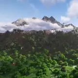
Map images:


List of the biomes used:
Plains
River
Desert
Beach
Meadow
Forest
Flower Forest
Taiga
Mangroove Swamp
Swamp
The altitude of the terrain in the real world ranges from 0m to 257m asl
In Minecraft, the lowest point of the terrain on the map is at 62, while the highest point is at 319, with a vertical resolution of 20m.
Water level is at 62, while the maximum building height is 319.
Map details:
Map name: Mississippi, USA - 1:20 scale
Map size: 21435x33191
Map resolution: 1 block in the game corresponds to 20m in the real world
Map files size: - 11.7gb uncompressed, - 7.66gb compressed
Minecraft version: 1.18+
Data used to process the map:
3DEP 1/3arcsec DEM data for the Terrain Elevation - cubic reinterpolation to 20m resolution
NLCD 2021 Land Cover at 30m resolution data for biomes positioning - cubic reinterpolation to 20m resolution
Open Street Map data for trees, vegetation, waypoints, coastlines, rivers, streams and beaches positioning - rasterization to 20m resolution
Bugs are always possible, please report them!
In-game Screenshots:


To download the map you have to install a torrent client (for example uTorrent or BitTorrent). With the client you can open the .torrent file and download the map